GRSG 2016 Annual Conference Presentations
Future of Geological Remote Sensing:
Innovation and Challenges
The 2016 conference, hosted at Arup, Fitzroy street, London focused on the usual wide range of GRSG topics on Oil and Gas, Geological Mapping, Minerals, and Technological advances with an additional focus on Engineering applications. With difficult market conditions the GRSG was delighted to welcome such a wide range of diverse, high quality and interesting presentations a number of which are available for download below.
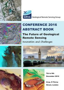
To download one of the presentations from the conference please follow the links in the tables below and to download a PDF copy of the Conference Guide and Abstract Book just click on the image.
Day 1
| Presentation Title | Author | Organisation | Download Link |
|---|---|---|---|
| Relationship between gamma radiation and light spectrum using airborne survey and Worldview-2 in South Portuguese zone, Portugal. | Gabriel Barberes | University of Coimbra, Portugal | Click to download |
| LIME: Interpretation, visualisation and communication of 3D models in geoscience | Simon Buckley | Uni Research CIPR | Click to download |
| Continuous, Remote and Long-Term Tunnelling Monitoring with InSAR | Alessandro Ferretti | Altamira- TRE | Click to download |
| EnVision: The Proposal for Europe’s Revolutionary New Mission to Venus | Richard Ghail | Imperial College | Click to download |
| Introduction to GBDX | Alex Gow | DigitalGlobe | Click to download |
| Developing UAV systems for landscape and atmosphere monitoring at the British Geological Survey | Colm Jordan | BGS | Click to download |
| Implementing the change vector analysis technique for assessing spatiotemporal dynamics of land-use and land-cover in the Mu Us Sandy Land, China | Prof. Arnon Karnieli, | Ben-Gurion University of the Negev, Israel | Click to download |
| Natural hazard risk mitigation in mountain environments – the role of remote sensing | Jason Manning | Arup | Click to download |
| Crossrail’s InSAR case study and potential future applications in the construction industry | Javier González Martí | Crossrail | Click to download |
| Boat based mapping of geological features using 3D-Photogrammetry and hyperspectral imaging system (Case study: Greenland) | Sara Salehi | GEUS | Click to download |
Day 2
| Presentation Title | Author | Organisation | Download Link |
|---|---|---|---|
| Spectral Geology and Remote Sensing used for Mineral Exploration in the Abu Marawat Concession, Eastern Desert, Egypt | Micky Brown | Mappa Mundi | Click to download |
| Mineral Mapping of Core Using Combined High-Resolution SWIR and LWIR Sensors | David Browning | Terracore | Click to download |
| The influence of basement structure and drainage networks on prospectivity in the East African Rift System | Rowan Edwards | CGG NPA | Click to download |
| Characterizing Hydrothermal Alteration Using WorldView-3 and ASTER Data in the High-Sulfidation Epithermal Jagüelito Deposit, San Juan, Argentina | Prof Diego Fernando Ducart | UNICAMP | Click to download |
| Remote Sensing of the Copper Creek District, Arizona. Results from Aster, Airborne Hyperspectral and Field Spectroscopy | Marc Goossens | Geosense | Click to download |
| Support applications in shallow water and coastal zone: Advances in Satellite Derived bathymetry and seafloor mapping and monitoring | Dr Peter Hausknecht | Earth-i | Click to download |
| Introduction to the EO Broker Energy platform | Anoop Pandey | Satellite Applications Catapult | Click to download |
| Hot stones: mapping igneous kimberlites under Kalahari cover using LWIR imagery | Neil Pendock | Consultant, | Click to download |
| Geomorphometric characteristic of selected fossil landslides in the Vipava Valley, SW Slovenia | Tomislav Popit | University of Ljubljana | Click to download |
| Hyperspectral mineralogical and lithological mapping of metasediments and metavolcanics of Gamsberg, Aggeneys, South Africa. | Dr Martin Schodlok | BGR | Click to download |
| Distribution of hydrothermally altered zones and their relation with fracture patterns at the Domeyko range between 20° 35’ S and 21° 17’S, (Región de Tarapacá, Chile): a remote sensing and GIS study | Byron Szadman | Universidad de Chile | Click to download |
Day 3
| Presentation Title | Author | Organisation | Download Link |
|---|---|---|---|
| Comparison between linear and non linear spectral unmixing methods for hyperspectral data | Asmau Muktar Ahmed | University of Kingston | Click to download |
| GEO: Earth Observations for managing Minerals and Non-renewable Energy Resources | Stephane Chevrel | BRGM | Click to download |
| Keynote: Australia’s Version 2 ASTER mineral maps unmixed of the effects of green and dry vegetation | Tom Cudahy | CSIRO | Click to download |
| Operational ice charting in mid-latitudes using Near Real Time SAR imagery | Carles Debart | KSAT | Click to download |
| High spatial resolution satellite Earth Observation – a reliable tool for site monitoring across Mining, Oil and Gas and Engineering | Dr Peter Hausknecht | Earth-i | Click to download |
| ASTER Value-Added product | Koki Iwao | AIST | Click to download |
| The copper mining cycle in Chile - application of EO data and digital mapping techniques | Tom Jones | Satellite Applications Catapult | Click to download |
| Airbus DS Data Portal – Meeting the changing requirements of the Remote Sensing community | Alasdair Kyle | Defense and Space | Click to download |
| Characterization of tight shales from spectral imagery of drill core | Benoit Rivard | University of Alberta | Click to download |
