Review of the 29th GRSG Annual Conference and AGM
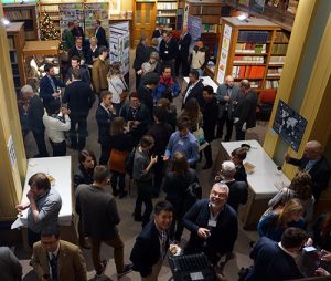 The 29th GRSG Annual Conference and AGM saw more than 100 attendees come together at the world-famous Geological Society on London’s Piccadilly.
This multidisciplinary event brought together researchers, students and professionals from commercial companies, all with an interest in recent developments in geological remote sensing.
Charlotte Bishop, the current chairman, warmly welcomed all the participants and the conference was opened by Jeremy Wrathall of Cornish Lithium, UK who gave the keynote talk on the EO techniques deployed by his company in Cornwall whilst also highlighting the challenges they face with such exploration.
The 3-day conference was divided across the following themes/topics: Oil and Gas, New Technology, Applications and Innovations, Mineral Exploration, Geological Mapping/Mapping techniques and InSAR & Geohazards which provided a broad spread of remote sensing technology from ground, to air to space across a wealth of applications.
Oil and Gas Sessions 1 and 2 were inspiring collections of talks that highlighted the potential of EO data and techniques to get better understanding of tectonics and geomorphology, demonstrating the relationship between petroleum and remote sensing, proving that thermal airborne data can be used to detect petroleum hydrocarbons (PHC) in mixtures with mineral substrates, showing advantages of using close-range spectroscopy together with multi-source satellite remote sensing data and presenting that a new class of spectrometer makes it possible to observe key absorption features in coal.
Speakers from the two “New Technologies, Applications and Innovations” sessions brought our attention to the proposed EnVision mission (medium class, ESA M5) presenting its potential to determine the nature and current state of geological activity on Venus. Other innovative technologies were further presented: inter-comparison and rigorous analysis of UAVs and UAV-based hyperspectral imagers, demonstrations on how satellite remote sensing and open source DInSAR processing can assist with disaster risk reduction (DRR) and climate change adaptation (CCA), how the world’s first, and so far the only satellite, – GHGSat – can assist to measure greenhouse gas emissions (CO2 and methane) and how the new PCI Geomatics image processing tools can help to derive Analysis Ready Data.
These challenging talks were closed with activity overview of the P4001 Hyperspectral Standards Working Group.
 When listening to talks across the Mineral exploration sessionsit was a great chance to find out latest news about recent trends in hydrothermal alteration mapping using diverse satellite data such as ASTER, Landsat, and Sentinel data. The long history of use of ASTER and Landsat continues to be highlighted showing their continued importance within this industry despite their age.
The wealth of data and development of new algorithms being a large factor to their usability and indeed reliability. In addition two inspiring talks demonstrated potential of the WorldView-3 data for mapping key alteration minerals. These talks were followed by great demonstrations of advantages of hyperspectral techniques to map mineral resources in the Arctic and in the western belt of the Postmasburg manganese-field, South Africa. At the end, innovative satellite-based techniques bringing potential to reduce the cost of lithium exploration substantially were presented.
How the first geodetic satellite data (Geosat, US Navy) can be used to get better understanding about the tectonic evolution of the East African Rift was discussed in the Geological mapping session. This session was thematically followed by Mapping Techniques where we have seen how Sentinel-2 data can be employed to monitor Acid Mine Drainage, further the synergic use of multi-mission Optical and SAR data was demonstrated as well as advantages of high-resolution Digital Elevation Models (DEMs) which can be extracted from very high-resolution (VHR) optical satellite imagery.
Last but not least, latest development in applying InSAR was presented. Where we heard inspiring talks about the status of the PSI-based German ground motion service, how InSAR can be combined together with polarimetry to determine land cover/soil moisture, to monitor cliff collapses or used for upstream Oil&Gas. Furthermore, the capability of new generation radar satellites (Sentinel-1, TerraSAR-X or COSMO-SkyMed) to provide deformation information of high spatial detail at a significantly greater revisit rate was demonstrated.
Overall, attending the 29th GRSG Annual Conference was a fantastic learning and networking opportunity, and I would highly recommend attending this conference in 2019 when the community will be celebrating 30th anniversary.
Written by Veronika Kopackova, Czech Geological Survey


