ASTRALiTe’s 2-in-1 Topo-Bathy LiDAR Maps Underwater Pipeline in Coral Reef
ASTRALiTe has successfully demonstrated its 2-in-1 Topo-Bathy LiDAR flying on a DJI Matrice 600 Pro UAV during three separate missions over the course of a month in Colorado and Hawaii.
“This is a significant achievement in miniaturization! Bathymetry from a medium-sized UAV platform is now just as easy to perform as topographic LiDAR surveys”, said, Gerald Thompson, VP of Operations for ASTRALiTe. “It’s a breakthrough to have a bathymetric scanning lidar system capable of working on the widely available DJI Matrice UAV. It opens up whole new business areas.”
The images shown below were captured during the Applied Research Lab (ARL) MANTAS II 2018 Tech Demo at the University of Hawaii’s Institute of Marine Biology (HIMB) on Coconut Island. The LiDAR was flown over a coral reef and mapped a boat channel and lagoon at cm-level resolution.
The image on the left shows the point-of-view from the drone (GoPro image), and the figure on the right is that same scene as a point cloud image captured by the LiDAR system. Note the 6” pipeline that runs through the center of the image, and the corresponding pipeline that is clearly visible in the 3-D point cloud figure on the right.
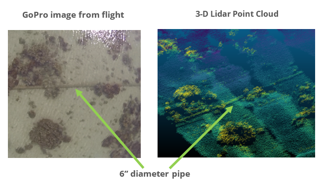 This bathymetric LiDAR data demonstrates the potential applications to oil and gas pipeline mapping of critical underwater assets, including location and state information needed to make operational decisions.
The LiDAR runs on its own self-contained battery, saving the drone batteries and enabling more air time. Even with medium-to-high winds, the M600 Pro was able to handle the 5 kg LiDAR payload, and was able to collect centimeter-level bathymetric lidar data in each of 13 flights.
The largest mission conducted was at ARL in Oahu, HI, where the LiDAR system was put to the test on the windward side of the island in rough conditions that included salt spray and significant surf over the course of three days. The expert ARL staff piloted the Matrice 600 Pro masterfully in these conditions, collecting near-shore bathymetry, dune, inlet and lagoon profiles, and mapping underwater coral reef structures at centimeter-level resolution. A total of seven flights were conducted, the longest being 17 min.
Please contact us at contact@astralite.net, or visit www.astralite.net for more information.


