Remote Sensing for Oil and Gas Exploration & Development
![]() Date & Times: 9:30 am – 4:00 pm, 12th June 2019
Date & Times: 9:30 am – 4:00 pm, 12th June 2019
Location: PESGB Offices, 3rd Floor, Welby House, 96 Wilton Road, London, SW1V 1DW
This course is part of the PESGB Series of Technical Excellence Workshops and will explore how satellite remote sensing can be used to reduce risk, save time and deliver a more complete picture across the oil and gas lifecycle.
The course is available to all PESGB Members but will be relevant to anyone working in oil & gas exploration, pollution monitoring and / or onshore reservoir monitoring.
 Agenda – Morning
Introduction to remote sensing – Hayley Larkin – Remote Sensing Specialist
Basic principle of remote sensing including: the electromagnetic spectrum, orbits, resolution, data types, processing and key satellites
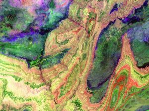
Remote sensing for onshore exploration – Jorge Gines – Senior Structural Geologist
Introduction to photo geology principles covering interpretation of geological features from satellite imagery including: folds, faults, fracture networks and lithostratigraphic units. In addition, the use of DEM’s for extraction of dip and strike measurements will be demonstrated and examples of how to extrapolate into the sub surface will be shown.
 Agenda – Afternoon
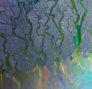
Remote sensing for offshore exploration – Mike King – Oil & Gas Manager
Introduction to seepage slicks and offshore seepage detection covering: why are seeps significant, data selection, interpretation, classification and validation
Introduction to ground motion detection using InSAR – Rachel Holley – Senior InSAR Scientist
Module will demonstrate the principles of satellite based InSAR ground monitoring detection with examples of its application to exploration but with a focus on shallow reservoir monitoring.
Please note, lunch will not be provided – there are many cafes/restaurants/shops within walking distance, or people are welcome to bring a packed lunch.
CLICK TO REGISTER FOR THE PESGB COURSE
Speaker Bios
Mike King – Oil & Gas Manager
Mike has a background in Geology and Remote Sensing with over 15 years’ experience in using Remote Sensing for Oil and Gas exploration. His current role oversees all of the geological remote sensing products for NPA and include the world leading Seep Explorer database and onshore geological mapping services.
Jorge Gines – Senior Structural Geologist
Jorge is a structural geologist and has been with CGG for over 10 years. Keen in the evolution of fold-and-thrust belts, his role involves geological mapping and interpretation of satellite data, and construction of geological models and cross-sections for oil and gas and mineral exploration.
Hayley Larkin – Remote Sensing Specialist
Hayley is part of NPA’s Imagery and Data Services team focusing on technical sales, enquiries and business development. Her main focus is on the use of optical imagery and elevation data to look at land cover, environmental change, logistics and mapping to support exploration activities.
Rachel Holley – Senior InSAR scientist
Rachel leads the development activities of NPA’s InSAR Surveying team and has maintained a strong technical background through a variety of commercial and publicly-funded research projects. She has particular experience using satellite imagery processing techniques in challenging terrain for volcanological and natural hazard applications, oil and gas field deformation and geothermal areas.


